Governor, We Have A Breach!
March 18, 2019
October 28th, 2012:
7:00pm: MTA shuts down subway and commuter rail services in New York City and Long Island. The New York City Stock Exchange shuts down for the first time in 27 years.
9:00pm: Bus services are suspended across New York. President Obama and Governor Cuomo declare a State of Emergency in New York.
12:00pm: The New York Port Authority suspends all train services. All airports in New York are shut down until further notice.
October 29th, 2012:
8:00am: Waves in the Long Island Sound and New York/New Jersey Bight are a record 10 feet high. Authorities are overwhelmed with calls concerning down power lines, trees, billboards, and faces of buildings.
2:00pm: Governor Cuomo closes all tunnels below sea level in New York City.
4:00pm: Closings begin for dozens of bridges across New York.
5:55pm: New York City Mayor Michael Bloomberg issues a statement saying that it is too late to abide by the mandatory evacuation protocols issued. With all forms of transportation in New York shut down, there is simply no place to go.
6:00pm: Sea water has breached natural Long Island barrier walls and sand dunes, allowing water to flow onto the Island without resistance.
9:00pm: Flooding as caused a major explosion at a Manhattan ConEd facility. All of Lower Manhattan is plunged into darkness as the blast creates an aftershock similar to an earthquake. Collectively, there are roughly 7 million power outages across New York.
9:19pm: Emergency services report that the New York 911 Operating System is receiving over 10,000 calls every half hour.
11:00pm: A fire breaks out in Queens, burning 110 homes over multiple blocks. Emergency Services begin using boats to perform rescues, although many are hopeless.
October 30th, 2012:
9:00am: Water levels across Long Island and New York begin to recede. Authorities continue to perform rescues.
November 28th, 2012:
4:00pm: Governor Cuomo says Sandy has cost New York state $41.9 billion, including $32.8 billion in repair and restoration costs and $9.1 billion in mitigation and prevention fees. More than 100 million miles of shoreline beaches are severely eroded.
In 2012, conspiracy theorists believed that the world was to come to an end as the 5,000 year Mayan Calendar ended on December 21st, 2012. Although the timeline above does not depict the end of the world, it sure did feel like that for millions of Eastern Seaboard residents when Hurricane Sandy slammed the coast from October 26th, 2012 to October 31st, 2018, causing over $65 billion in damage. Yet, over six years later, New York is still struggling to recover.
Where as many Long Islanders are finally getting back to their normal lives and are almost fully recovered, the island itself is still under the impact of Sandy. This includes the breach of Long Island’s natural barrier walls on October 29th, 2018 at 6:00pm. As of the publication of this article, two of the tree breaches have been filled, while the third breach, located in the Otis Pike High Dune Wilderness on the eastern half of the Fire Island National Seashore, still remains open.
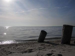
A barrier island is defined by Google as “a long, narrow island lying parallel and close to the mainland, protecting the mainland from erosion and storms”. For Long Island, barrier islands include Coney Island, Long Beach Barrier Island, Island Park, Jones Beach Island, Fire Island and Westhampton Island. These islands, known as the “Outer Barrier”, act as protection for Long Island, as waves from the Atlantic Ocean are slowed by the barrier islands before the waves can reach the mainland and cause critical damage. Yet, when the waves are exceptionally tall and travel fast, they can breach the island, meaning that they can push the sand away, dividing the island and making a channel that connects the waterways on both sides of that island. While some are small and repairable, other like that of Fire Island, which now connects the Atlantic Ocean to the Great South Bay, can be too wide or deep to repair easily, and for that reason has remained open.
But what exactly does this mean for the Great South Bay, and the ocean life surrounding those waters? First, there is the physical state of the water itself which has changed. Although both sides of the barrier wall contained salt water, the salt levels, known as the salinity, of each body were incredibly different. The breach has caused saltier water from the Atlantic Ocean to flow into the bay, increasing the salinity of the bay from 24 parts per thousand to 32 parts per thousand. This means that the water in the bay is now at the same state of salinity as the ocean, an occurrence which has not happened since the barrier island was formed in the 1850s. Naturally, if the state of the water in an aquatic ecosystem changes, so does everything else.
The increase in salinity of the water has attracted a different type of ecosystem to the bay, involving more salt-loving creatures. Scientists have noticed an increase in predators like summer and windowpane flounder, striped bass, sea robins, bluefish and mantis shrimp compared to populations in a 2007 study. There has also been a chance in the species of crabs present, as the populations of blue crabs has dropped and been replaces by lady crabs and horseshoe crab populations. Fisherman have taken great notice of the new ecosystems, noting that marinas have been struggling since the oyster populations began decreasing years ago. Many marinas claim that the new ecosystems have boosted local fishing and crabbing businesses, supporting the Long Island economy. Scientists at Stony Brook University also recognise the change in the ecosystems of the Great South Bay, claiming that there is now a stronger, more stable, and dynamic ecosystem present in the Bay.
Some scientists have even gone on to praise that the channel connecting the bodies of water is not just replacing the water in the bay with more salitable water, but it is actually improving the quality of the water altogether. As stated in my previous publication, “Who Needs Clean Water, Anyways?”, the strong nitrogen levels in the water have been causing a recurring browntide, killing many fish and organisms in the water. Yet, with this new channel open, researchers claim that the current moving water into the bay is also pulling toxic water out of the bay, cleaning up the nitrogen issue from runoff. This has also been the reason behind the new, thriving ecosystems, scientist say.
The connecting channel does, however, have it’s downfall. Just as the current can be beneficial for clearing up the water in the Great South Bay, it also increasing the risk of tidal effects on the now exposed coast. One of the great benefits of a barrier island is that it acts as a barrier, and with the barrier breached the coast of the mainland is vulnerable to increased flooding and erosion from storms. Towns bordering the Great South Bay, specifically Lindenhurst, suffered millions of dollars worth of damage when flood waters reached nearly a half mile inland, reaching up to Montauk Highway. Are the benefits of the breach worth the risk it poses to South Shore communities? It seems that with every advantage, a new disadvantage arises.